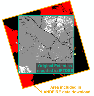
Spatial Extent of IFTDSS and LANDFIRE data
If you use IFTDSS extents to download additional layers from the LANDFIRE Data Distribution site, or alternate between working in IFTDSS and working outside IFTDSS with LANDFIRE layers, note that:
- IFTDSS uses the WGS 84 coordinate system, which is different from that used on LANDFIRE's Data Distribution site
- The LANDFIRE Data Distribution site will clip a raster to fit the coordinates you enter, though the resulting data may cover a larger area, as the example figure below shows:

To completely match the extent of IFTDSS landscapes when downloading additional layers from LANDFIRE, be sure to clip your newly downloaded LANDFIRE landscape to the initial extent of the IFTDSS landscape.
You may also upload and use polygons in IFTDSS that partially fall outside of your landscape boundaries. Any model runs will only capture the area of the polygon that overlaps with the IFTDSS landscape extent.