Important! Treatments that are removed from the official system of record are still present in FTEM. The team is currently working to better synchronize this process.
Note: Treatment dates contained within FTEM vary by their source and include:
-
FACTS treatments completed after Jan. 1 2005.
-
NFPORS completed during or after 2008.
-
IFPRS treatments after Oct. 2023 for all DOI agencies except BLM, which began using IFPRS in Oct. 2024.
-
All other treatments completed less than ten years ago.
This technical documentation page contains the following sections:
Introduction
The Fuels Treatment Effectiveness Monitoring (FTEM) process relies on Integrated Interagency Fuels Treatment geospatial datasets that depict completed fuels treatments from four land management Agencies within the Department of Interior (National Park Service, Bureau of Land Management, US Fish and Wildlife Service, and Bureau of Indian Affairs) as well as the Department of Agriculture (USDA Forest Service). These spatial datasets consist of point and polygon features.
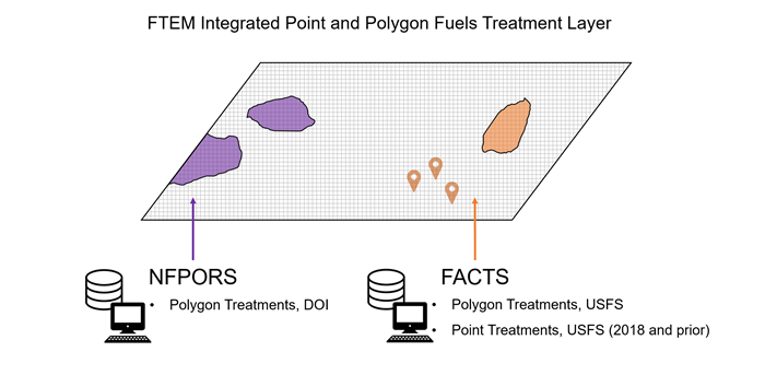
Treatments in FTEM come from the FTEM Integrated Point and Polygon Fuels Treatment Layers which is derived from data stored in:
-
The Interior Fuels and Post-fire Reporting System (IFPRS). Note: BIA, FWS, and NPS made the transition from reporting in the National Fire Plan Operations and Reporting System (NFPORS) to IFPRS in October of 2023, while BLM began to report in the new system in October 2024.
- The National Fire Plan Operations and Reporting System (NFPORS) Hazardous Fuels Reduction (HFR) Module. NFPORS was the national system for tracking combined fuels accomplishments for all agencies in the Department of Interior before being replaced by IFPRS.
- The Forest Service Activity Tracking System (FACTS). FACTS is the official system for tracking USDA Forest Service fuels accomplishments. FACTS data was shared with NPFORS and is currently shared with IFPRS to facilitate interagency reporting needs.
Combining Data Sources
Though FACTS point data is shared with IFPRS, polygon data from the USDA Forest Service in not. This is due to the individual histories and data structures of the two applications, which originated with different end goals.
Point features represent all treatment records, from FACTS and IFPRS; However, not all treatment records have an associated polygon due to variability in agency-specific reporting rules and system capabilities. This is especially true for older treatments. Another complicating factor is that different systems of record use different attribute names, or fields, to describe similar information related to fuels treatments.
To overcome these challenges, the FTEM team created two fuels treatment layers, one point layer and one polygon layer. Together, these layers represent an integrated depiction of completed fuels treatments across five federal agencies. The FTEM Integrated Point and Polygon Fuels Treatment Layers:
- Draw spatial and tabular information from FACTS, IFPRS, and NFPORS.
- Contain attributes that are cross-walked to the NWCG Fuel Treatment Polygon standard (see below for more detail on this process).
- Are automatically updated nightly to reflect newly entered and revised data.
- Are filtered to remove duplicate records, where possible.
Creating a Common Standard
Combining IFPRS and FACTS polygon data into the FTEM Integrated Point and Polygon Fuels Treatment Layers was accomplished by using the National Wildfire Coordinating Group (NWCG) data standard for fuels treatments to identify the minimum attributes required the use of fuel treatment data. NWCG standards provide specifications for data that enable common usage across wildland fire information systems (https://www.nwcg.gov/data-standards). After thoroughly reviewing FACTS and IFPRS polygon data, the FTEM team cross-walked treatment data from both sources to the standard and combined the resulting data from the respective systems to create a single service for all fuel treatment perimeters from both departments. This methodology includes a process to remove duplicate polygon records and duplicate point records.
The points within the FTEM Integrated Point and Polygon Fuels Treatment Layers are derived directly from IFPRS and maintain attribution as it exists in that system. No NWCG data standard for fuels treatment points currently exists, although the development of such a standard has been requested. This layer is filtered to remove those points that are already represented by polygons in the Interagency Fuels Treatments Polygon Service.
Inevitably, some duplication of points and or polygons remains due to variance in how records are populated in the system of record. In the case of polygons, duplication most often occurs when fuels treatment work has been done on the same piece of ground multiple times, usually as part of a series of activities considered part of the same treatment. For example, a thinning, followed by a piling activity, followed by a burning activity, might each be represented by separate, identical polygons. While steps have been taken to display only the most recent activity in these scenarios in order to reduce duplication, some of the source data are organized in such a way that this is prohibitively difficult. Thus, some duplicates remain in the integrated data. However, this integration is first of its kind. No other cross-agency, integrated polygon and point coverage of completed fuels treatments currently exists.
Important! Treatments completed 10 years or more prior to the fire start date are not automatically included in the treatment list. These treatments may be added to the list by increasing your treatment buffer and selecting them from the list of available treatments that appears, using the Add Treatment feature when viewing that treatment on the map.
Important! If you do not see a wildfire or fuel treatment in FTEM, it is likely because it has not been included in FACTS or IFPRS. Please follow up with your Agency Administrator to have the information added to the system.