About Wildfire Data Sources
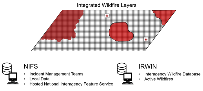
- The National Incident Feature Service (NIFS) . This service provides fire perimeter (polygon) data, where it exists.
- The Integrated Reporting of Wildland Fire Information (IRWIN) data exchange service. This service provides point locations and fire-related data for fires across the United States.
This topic covers:
How Wildfire Data is loaded into FTEM
Note: Basic criteria for including wildfire data in FTEM include:
-
Marked as Wildfire ("WF" code) in IRWIN
-
Has a valid IRWIN ID
Loading IRWIN Wildfire Point Data into FTEM
Point data is taken from IRWIN which can be thought of as a central hub orchestrating data between the various applications. IRWIN has interfaces with several systems:
- INFORM – Interagency Fire Occurrence Reporting Modules, used for reporting of wildland fire information integrated with IRWIN.
- IROC – Interagency Resource Ordering Capability used to order resources for wildland fires.
- WFDSS – The Wildland Fire Decision Support System, used to support decision making.
- Computer-Aided Dispatch (CAD) systems, used for managing information during Initial Attack and Extended Attack wildfire management activities at local units.
- The FireCode application used to generate financial codes for wildfires.
- The Sit/209 application used to track the status of large or significant fires.
All data for an incident is linked to a single unique identification code (ID) associated with that unique wildland fire incident. By linking all data for an incident to a single ID, IRWIN is a convenient “one-stop shop” for information on specific fires from many wildland fire computer systems.
Important! If you do not see a wildfire or fuel treatment in FTEM, it is likely because it has not been included in one of the above systems. Please follow FAQ on Wildfires and up with your Agency Administrator if necessary to have the information added to the system.
Loading NIFS Wildfire Perimeters into FTEM
Wildfire perimeters, represented as polygon features, are collected and made available using NIFS. The wildfire dataset contains current, active wildfires. Perimeter data comes from a variety of sources:
- Trained incident GISS specialists
- Infrared interpreters
- Field observers
- Incident operations resources
- Agency staff
Note: Note: Some perimeters may not be approved by an incident or agency for public distribution (FeatureAccess <> Public or FeatureStatus <> Approved or FeatureStatus <> Proposed).
How often wildfire data updates
NIFS data is uploaded to FTEM nightly. Updates by the GISS to NIFS occur in near real-time via the Hosted National Incident Feature Edit services if the incident has a reliable internet connection. In cases where a reliable internet connection is unavailable, local edits are synced nightly and it is possible NIFS may not always reflect current conditions on the ground. For a better understanding of the workflows involved in mapping and sharing fire perimeter data, please see the NWCG Standards for Geospatial Operations, PMS 936 .
Note: Nightly automated FTEM push is to bring in NEW fires. If a fire changes from Type="wildfire" to something else, for example an incident is erroneously labeled a wildfire and later corrected, it will remain in FTEM until manually removed by data staff. If monitoring was initiated, all monitoring must be removed before the incident can be removed from the system.
Where to find detailed technical documentation
See the Wildfire Technical Documentation topic for additional details on the criteria used to pull data into the system.