This topic covers:
Landscape Requirements
The following criteria must be met to ensure landscapes successfully upload and save to IFTDSS:
-
Bands numbering between 8 and 12.
-
Cells must be in meters.
-
File must not be within a zipped folder.
-
File name may not contain any special characters such as "."
-
File size maximum of 600 MB.
-
File type must be a GeoTIFF (*.tif).
-
Pixel count must be under 60,000,000.
-
Pixels must be square (have the same height and width).
-
Pixel type must be integer.
-
Projection must be defined.
-
No more than 50% of the landscape area may be "NoData" cells.
-
Resolution can range from 1 to 270 meters.
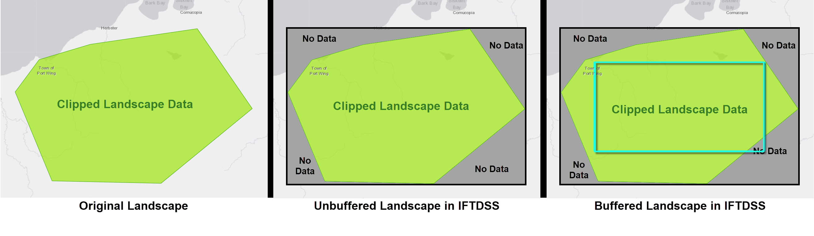
Using Clipped Landscapes
Tip: It's recommended to upload a landscape that's rectangular in extent and larger than your analysis area. This allows for a buffer to be created and also helps avoid gaps in landscape data. Areas of Interest can always be created later in IFTDSS and applied to reports or used as a mask when viewing outputs.
Clipped landscapes, when uploaded to IFTDSS, will have a rectangular extent based on the outer edges of the landscape.
If there are gaps between the clipped landscape and the edge of that rectangular extent, they will be represented as "No Data."
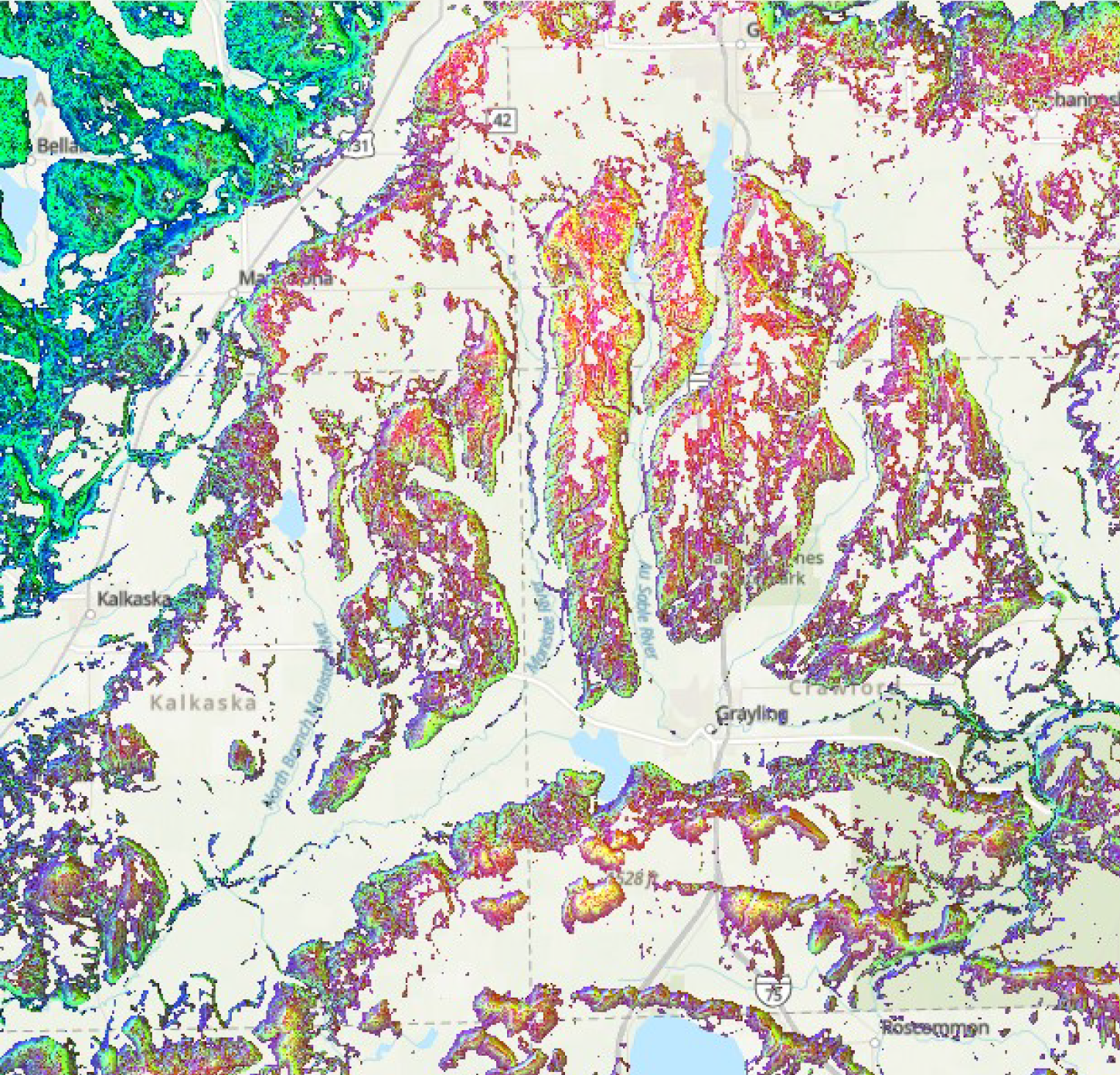
Gaps in Data Coverage
Important! Use caution when running landscape fire behavior models with uploaded landscapes that have gaps in data. These may run successfully in fire models but the areas with gaps will appear as non-burnable. This may or may not be the case on the ground. See the example below for more detail.
The below landscape has gaps in the 'aspect' layer. If it is run with MTT Fire Spread these areas will appear in the output as non-burnable. However these same areas do have fuel model and canopy data. Had the 'aspect' layer had full coverage, the resulting model outputs, such as fire spread, may be very different.
Band Checks
Note: Band check status can be view in My Workspace
Band checks include the following to ensure uploaded landscapes run successfully when used for Landscape Fire Behavior, MTT Fire Spread, or Landscape Burn Probability:
-
No data – preference no data is –9999 by the models and up to 50% may be present.
-
Band 1 = Elevation (m): -100 to 8,900.
-
Band 2 = Slope (degrees): 0 to 90.
-
Band 3 = Aspect (degrees/azimuth): -1 to 360.
-
Band 4 = Fuel Model (categorical): 1-13, 91-93, 98-99, 101-109, 121-124, 141-149, 161-165, 181-189, 201-204. This is a pixel-level check since it is not a range.
-
Band 5 = Canopy Cover (%): 0 to 100.
-
Band 6 = Canopy Height (meters *10): 0 to 1200.
-
Band 7 = Canopy Base Height (meters *10): must be equal or less than band 6. This will be a pixel level comparison and even 1 pixel violating the rule will result in a failure.
-
Band 8 = Canopy Bulk Density (kg / m^3 * 100): 0 to 50.
Projection Validation
Note: Projection validation status can be view in My Workspace
Projection validation rules for GeoTIFFs:
-
If the convergence angle is < 5, the landscape GeoTIFF is not reprojected.
-
If the convergence angle is ≥ 5 and falls:
- Within the United States or Canada, it will be reprojected to the localized Albers North_America_Albers_Equal_Area_ Conic 102008 North America (Canada and USA including CONUS and the Alaska mainland 23.810 -172.540 86.460 -47.740.
- Outside of the United States or Canada extent indicated above, the landscape will be rejected. It must be reprojected to a north oriented projected coordinate system before it can be uploaded to IFTDSS.