Comparison of Fire Behavior Modeling Methods in IFTDSS
In IFTDSS, there are currently three models used to approximate fire behavior. Each of these models has unique strengths that help answer specific questions and meet specific objectives.
-
Landscape Fire Behavior
-
MTT Fire Spread
-
Landscape Burn Probability
Modeling in IFTDSS compared to other applications
Each of the above models comes from FlamMap , though you may also be familiar with them through using Wildland Fire Decision Support System (WFDSS). While the fire behavior calculations from these models are nearly identical in WFDSS and IFTDSS, they are named differently in each application and may have different fixed inputs or have slightly different assumptions based on how the developers built them into the application. If you are unsure, we recommend consulting the documentation in the application you are using for clarification. Each modeling section in the IFTDSS Help Center includes a Technical Documentation topic, such as this one for Landscape Fire Behavior.
Below is a table outlining the different naming conventions in IFTDSS, WFDSS, and FlamMap 6.1. For context, we’ve also included some other popular fire behavior modeling tools that may be included in one application but not the other.
| Model Name | Type | Name in FlamMap | Name in IFTDSS | Name in WFDSS |
|---|---|---|---|---|
| FlamMap | Static fire behavior | FlamMap | Landscape Fire Behavior | Under Development |
| Minimum Travel Time (MTT) | Fire spread | MTT | MTT Fire Spread | Under Development |
| Random Ignitions (Randig) | Burn probability | MTT | Landscape Burn Probability | N/A |
| Fire Area Simulator (FARSITE) | Fire spread | FARSITE | N/A | Under Development |
| Fire Spread Probability (FSPro) | Burn probability | N/A | N/A | FSPro |
| Large Fire Simulator (FSim) | Burn probability | N/A | N/A | N/A |
Not all applications have the same models. For example, FlamMap 6.1 and IFTDSS do not include FSPro while WFDSS does. Additionally, some applications may have more than one choice for a given model type. In FlamMap for example, fire spread can be calculated using either FARSITE or Minimum Travel Time.
Choosing a model
Choosing which model to use depends upon the question(s) you are trying to answer. Some questions may best be addressed by a single model while others could be answered using one of several models.
Different Modeling Approaches
The three models approach fire behavior modeling differently. For example,Landscape Fire Behavior maps fire behavior for a “snapshot" in time. It models head fire only and fire does not spread across the landscape – every pixel burns and every pixel is modeled independently, ignoring neighboring pixels.
In contrast, MTT Fire Spread and Landscape Burn Probability spread fire across the landscape from ignition(s). These models include heading, backing and flanking fire, which can result in lower intensity than Landscape Fire Behavior. Where these models differ is that MTT Fire Spread requires you to specify an ignition location and the model simulates a single fire from that location. The Landscape Burn Probability simulates thousands of fires from random point ignitions assigned by the model. In addition, MTT Fire Spread can be simulated for up to 5 burn periods; Landscape Burn Probability uses a single burn period.
| Landscape Fire Behavior | MTT Fire Spread | Landscape Burn Probability | |
|---|---|---|---|
| Weather conditions | Weather conditions remain constant throughout the entire simulation time. | ||
| Types of fire spread modeled | Head fire | Head, flanking and backing fire. | |
| Predicted Fire Behavior | Maximum | Based on type of fire spread (head, flank or backing fire). | Probabilistic flame length based on the mean intensity of all the times it burned. |
| Fire Spread | Fire behavior calculated independently for each pixel. | Fire spread is modeled across pixels based on Minimum Travel Time algorithm. | |
| Spotting | Not modeled. | Modeled and influences fire spread. | |
| Output Type | Deterministic – based on set inputs that you specify. | Deterministic – based on set inputs that you specify, spotting is stochastic, ignition is fixed. | Probabilistic – based on set inputs that you specify, spotting is stochastic, ignitions are random. Outputs are conditional probabilities based on thousands of simulated fires. |
Different Model Outputs
Each model offers unique outputs to support key analysis questions or decision making. The table below shows a list of outputs that can be viewed in the Map Studio (outputs are available for download as well).
| Landscape Fire Behavior | MTT Fire Spread | Landscape Burn Probability |
|---|---|---|
| Flame Length (ft) | N/A | Conditional Flame Length (ft) |
| Rate of Spread (chains/hr) | MTT Rate of Spread (chains/hr) | N/A |
| Fireline Intensity (BTU/ft-sec) | MTT Fireline Intensity (BTU/ft-sec) | N/A |
| Heat per Unit Area (BTU/ft2) | N/A | N/A |
| Crown Fire Activity | N/A | N/A |
| N/A | MTT Arrival Time | N/A |
| N/A | MTT Major Paths | N/A |
| N/A | N/A | Burn Probability |
| N/A | N/A | Integrated Hazard |
It is important to note the distinction between fire behavior outputs that, at first glance, may seem similar. For example, both the Landscape Fire Behavior model and the MTT Fire Spread model have a rate of spread output, yet they are not the same. Similarly, Flame Length and Conditional Flame Length from Landscape Fire Behavior and Landscape Burn Probability differ. These differences are due to differing model approaches discussed above. The subsections below explain these different examples in greater detail.
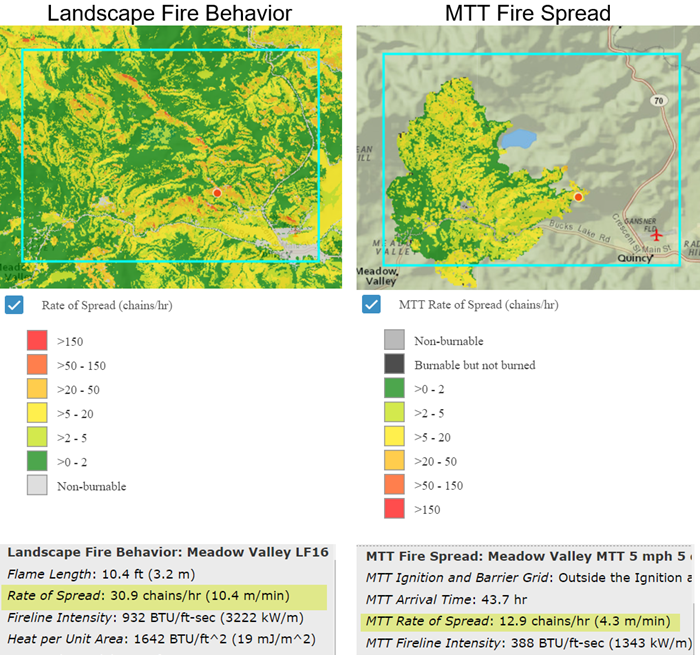
Rate of Spread versus MTT Rate of Spread
The example below maps rate of spread from Landscape Fire Behavior. Both simulations were completed on the same landscape using the same inputs for winds, crown fire inputs, initial fuel moistures, and fuel moisture conditioning. For MTT Fire Spread an ignition was also needed along with Simulation Time and Spotting.
Three things to notice when looking at these outputs:
-
The Landscape Fire Behavior output has values mapped for the entire extent. Whereas, MTT Fire Spread only has values mapped within the burned area.
-
Although the values are binned the same way and use the same colors, the names of the layers are different. This different naming convention was chosen to help you differentiate between similar ouputs from different models.
-
Pixel-per-pixel, rate of spread from Landscape Fire Behavior is usually higher than that from MTT Fire Spread. This is because Landscape Fire Behavior Rate of Spread is the maximum rate of spread (head fire), and MTT Fire Spread Rate of Spread is the based on the direction of the spread, which includes head, back and flanking fire.
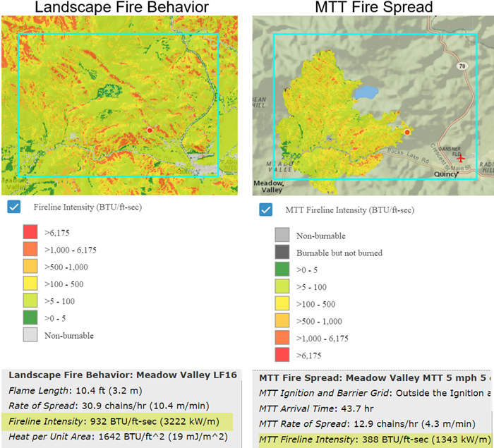
Fireline Intensity versus MTT Fireline Intensity
This example for fireline intensity uses the same model inputs as the Rate of Spread example above. You’ll notice the same differences as above, which exist for the same reasons:
-
Full coverage extent for Landscape Fire Behavior versus a specific burn area for MTT Fire Spread.
-
Similar binning and color scheme but with a different naming convention.
-
Pixel-per-pixel, less fire line intensity in the MTT Fire Spread output due to its inclusion of head, back and flanking fire.
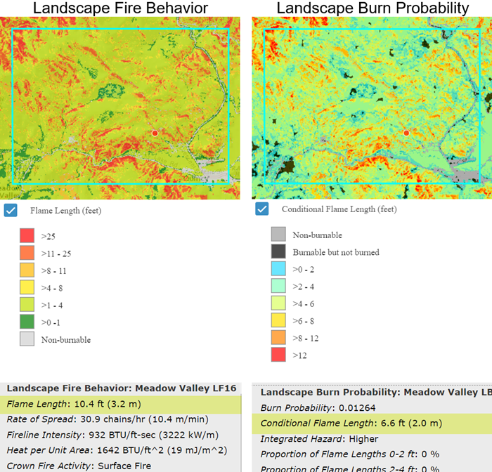
Flame Length versus Conditional Flame Length
The example below shows maps of flame length from Landscape Fire Behavior and Landscape Burn Probability. Both simulations were competed on the same landscape using the same inputs for winds, crown fire inputs, initial fuel moistures, and fuel moisture conditioning. For Landscape Burn Probability, Simulation Time and Spotting were also needed and ignitions are randomly applied by the model.
Two things to notice when looking at these outputs.
-
The bin classes, in addition to the colors, are different between the two models to help you distinguish that they represent two different types of flame length outputs.
-
Pixel-per-pixel, flame length from Landscape Fire Behavior will be higher than that of Landscape Burn Probability. This is because Flame Length is from head fire, and Conditional Flame Length is a mean value based on the probability of burning at a given intensity which includes the direction of the spread (head, back and flanking fire).