Important! Automatic resampling occurs in IFTDSS for all models to adjust the resolution of your landscape so it can successfully run in modeling applications.
Important! Landscapes that require resampling are not available for use in the Develop Treatment Alternatives (DTA) workflow.
Why Are Landscapes Resampled in IFTDSS
In IFTDSS, resampling is conducted to adjust the resolution of your landscape to allow it to meet the computation needs of modeling applications and run successfully. If you run a model that requires resampling by IFTDSS, such as LBP, you will notice the resampled landscape is generated and made available even before the model starts running. In short, this is done to allow the model to run faster.
Resampled landscapes are available in My Workspace. This is beneficial for understanding the underlying fuels/vegetation relating to the predicted fire behavior on each pixel.
When Are Landscapes Resampled in IFTDSS
Resampling only occurs when the pixel count for a landscape exceeds the maximum pixel limit for a given model. The maximum pixel count for each model in IFTDSS is shown in the table below.
| Model | Maximum Number of Pixels |
|---|---|
| Landscape Fire Behavior | 20,000,000 |
| MTT Fire Spread | 18,000,000 |
| Landscape Burn Probability | 1,500,000 |
When resampling, IFTDSS automatically selects the finest resolution that falls below the maximum pixel count.
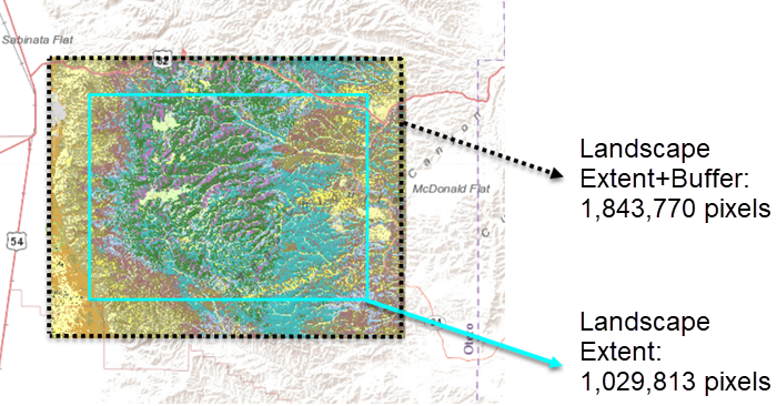
For example, the area below would be resampled to a 60-meter resolution when used for Landscape Burn Probability model. Although the landscape extent is less than the 1.5 million pixel maximum threshold, the buffer increases the overall area to 1.8 million pixels. This triggers resampling to the finest resolution that will fall below the 1.5 million pixel limit, in this case 60 meters.
Tip: To check a landscape pixel count, go to My Workspace, select the landscape to show metadata in the right-hand panel, and hover over the “Acres (Buffered)” field. This will display the total pixel count for your landscape and buffered area.
![]()
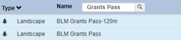
Landscapes that have been resampled are easily identified in IFTDSS by the landscape name, which has the resolution automatically added to the end. Those at the native 30m resolution do not have anything appended to the landscape name. For example, “BLM Grants Pass-120m” indicates that file has been resampled to a 120m resolution. And “BLM Grants Pass” is at the original 30m resolution. Landscape resolutions are also displayed in the Right-hand panel of the Workspace when the landscape is selected.
Where are Resampled Landscapes Available
Important! Important: Resampled landscapes may not be visible everywhere, see the text below for details.
Resampled landscapes can be used in My Modeling Playground for all models but you may not see some resampled landscapes for some model types. If a landscape has been resampled to work with one model, but still contains too many pixels for another model to process, it will only show up as an option for the models that can process it. This limitation exists to help with data integrity, avoiding scenarios where a landscape gets resampled multiple times.
Tip: Running a landscape through Landscape Burn Probability will resample the landscape to a resolution that will work in all other IFTDSS models. This is because LBP has the strictest limit on landscape size.
How Landscapes in IFTDSS are Resampled
Landscape resampling functions the same way in IFTDSS as it does in FlamMap. A “nearest-neighbor” method is used to complete the resampling. This ensures that widely scattered or narrow, linear elements of the fuelscape, like streams or roadways, remain represented in the re-sampled layers in proportion to their initial representation (Scott and others 2013).
Specifically, resampling:
- Starts from the upper left hand corner of the landscape.
-
Uses the center cell – if the center cell is at the intersection of 4 cells, it selects the cell above and to the left of the intersection.
-
If the selecting cell does not exist in the original landscape, no cell is generated for the resampled landscape. Thus, the size of the resampled landscape may be slightly larger or smaller than the original landscape.
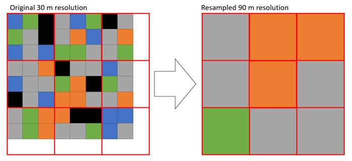
Resampling the same 30 m landscape to a 90 m landscape uses the center cell in each of the red boxes. However the final foot print is different because of how the resampling works, because there is a cell in the center, even though there are not enough cells to cover the full area a new cell is created along the bottom and right edges.
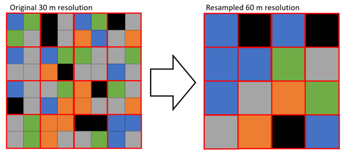
Below is an example of how resampling from 30 m to 60m resolution works. The red boxes are the outline of the new cell area. Because there is not a center cell in the new landscape, the upper left hand cell from the midpoint is used to create the resampled landscape.
Implications
The "nearest-neighbor" resampling retains scattered or narrow linear elements (e.g. roadways) on the resampled landscape in proportion to their representation on the original landscape. However as seen in the image above, resampling will result in a loss of some level of detail.
The resampled landscapes are saved in the same folder as the original landscape, and can be recognized by the resolution that is appended the file name (i.e. "landscape name-60m"). These landscapes are not available for editing in IFTDSS. Make edits to the original 30 meter landscape and use that for comparative runs. The edited 30 meter landscape will be automatically resampled during the model run, and appear in same Workspace folder as the others.
Currently, the resampling described below only occurs for landscapes run with the Landscape Burn Probability model.
In IFTDSS, resampling is conducted to adjust the resolution of your landscape to allow it to successfully run in some modeling applications.
Why
Resampling is necessary in IFTDSS in order to meet the intensive computational needs of the models. If you run a model that requires resampling by IFTDSS, such as LBP, you will notice the resampled landscape is generated and made available even before the model starts running. In short, this is done to allow the model to run faster.
The resampled landscape is available in My Workspace. This is beneficial for understanding the underlying fuels and vegetation relating to the predicted fire behavior on each pixel.
When
Resampling only occurs for landscapes submitted for Landscape Burn Probability runs when the landscape and the buffered area surrounding it exceeds 250,000 acres.
| Landscape Size (acres) | Resampled Resolution |
|---|---|
| <250,000 | 30 meters |
| 250,000 - <1 million | 60 meters |
| 1 million - <2.5 million | 90 meters |
| ≥2.5 million | 120 meters |
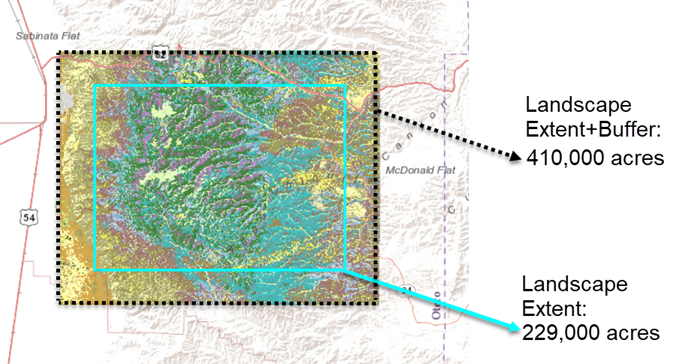
For example, the area above would be resampled to a 60 meter resolution. Although the landscape, shown with in the turquoise boundary is 229,000 acres, the buffer surrounding it increases the overall area to 410,000 acres, putting it in the size range for 60 meter resampling (250,000-<1 million acres).
Important! The Right Hand Panel displays acreages for your landscape that do not include the buffered area surrounding it. This may generate confusion as this buffered area is included in the landscape size used for resampling in IFTDSS.
Landscapes that have been resampled are easily identified in IFTDSS by the landscape name, which has the resolution automatically added to the end. Those at the native 30m resolution do not have anything appended to the landscape name. For example, “BLM Grants Pass-120m” indicates that file has been resampled to a 120m resolution. And “BLM Grants Pass” is at the original 30m resolution. Landscape resolutions are also displayed in the Right Hand Panel when the landscape is selected.
How
Landscape resampling functions the same way in IFTDSS as it does in FlamMap. A “nearest-neighbor” method is used to complete the resampling. This ensures that widely scattered or narrow, linear elements of the fuelscape, like streams or roadways, remain represented in the re-sampled layers in proportion to their initial representation (Scott and others 2013).
Specifically, resampling:
- Starts from the upper left hand corner of the landscape.
-
Uses the center cell – if the center cell is at the intersection of 4 cells, it selects the cell above and to the left of the intersection.
-
If the selecting cell does not exist in the original landscape, no cell is generated for the resampled landscape. Thus, the size of the resampled landscape may be slightly larger or smaller than the original landscape.
Resampling the same 30 m landscape to a 90 m landscape uses the center cell in each of the red boxes. However the final foot print is different because of how the resampling works, because there is a cell in the center, even though there are not enough cells to cover the full area a new cell is created along the bottom and right edges.
Below is an example of how resampling from 30 m to 60m resolution works. The red boxes are the outline of the new cell area. Because there is not a center cell in the new landscape, the upper left hand cell from the midpoint is used to create the resampled landscape.
Implications
The "nearest-neighbor" resampling retains scattered or narrow linear elements (e.g. roadways) on the resampled landscape in proportion to their representation on the original landscape. However as seen in the image above, resampling will result in a loss of some level of detail.
The resampled landscapes are saved in the same folder as the original landscape, and can be recognized by the resolution that is appended the file name (i.e. "landscape name-60m"). These landscapes are not available for editing in IFTDSS. Make edits to the original 30 meter landscape and use that for comparative runs. The edited 30 meter landscape will be automatically resampled during the model run, and appear in same Workspace folder as the others.