Important! Different than FSim - IFTDSS LBP calculates burn probability and conditional flame length for a fixed set of weather conditions for a single burn period. The Large Fire Simulation Model (FSim, Finney and others 2011) used in many national, regional, and unit level assessments, calculates results based on variable weather inputs for fires burning multiple days throughout an entire fire season.
See the LBP technical documentation for more detail.
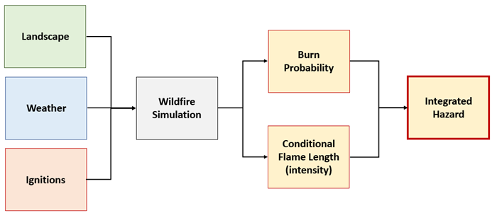
Landscape Burn Probability (LBP) quantifies the relative likelihood and intensity of a fire occurring under a fixed set of weather and fuel moisture conditions. Outputs include burn probability, conditional flame length and integrated hazard.
These outputs can be utilized as an independent product, or as part of a larger Quantitative Wildland Fire Risk Assessment, as shown in the workflow illustration below. The LBP model is the foundation of the Quantitative Wildland Fire Risk Assessment process (Scott and others 2013).
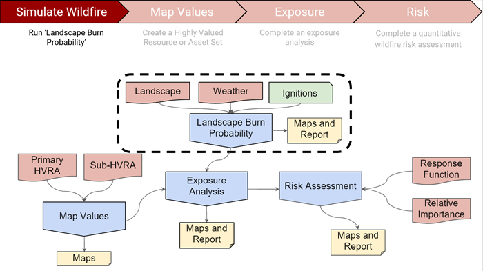
The LBP model is not as widely known as the more common fire spread models so it may be new to you. Please read the Modeling Considerations section to better understand how to use and apply this model to your work.
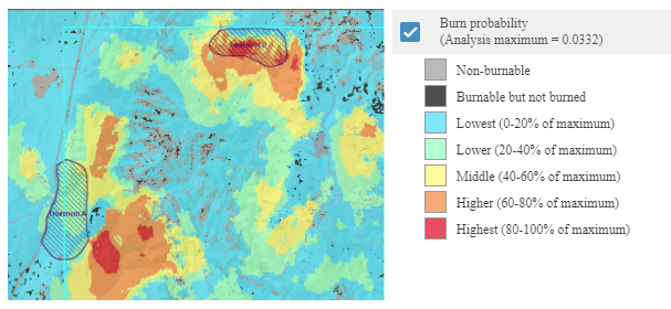
Burn Probability
Burn Probability quantifies the likelihood of a fire occurring under a fixed set of weather and fuel moisture conditions you input.
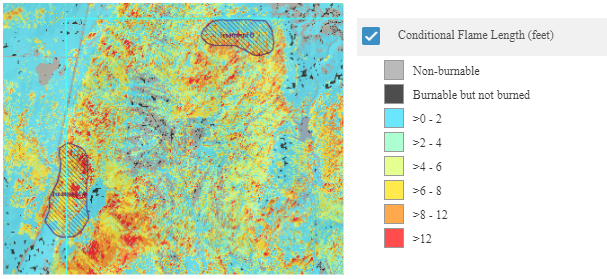
Conditional Flame Length
Conditional Flame Length is an estimate of the average flame length for all the fires that burn a given point on the landscape under a fixed set of weather and fuel moisture conditions.
Integrated Hazard
Integrated Hazard combines two of the LBP model outputs—burn probability and conditional flame length—into a single characteristic that can be mapped. In IFTDSS, we use the matrix below to map integrated hazard.
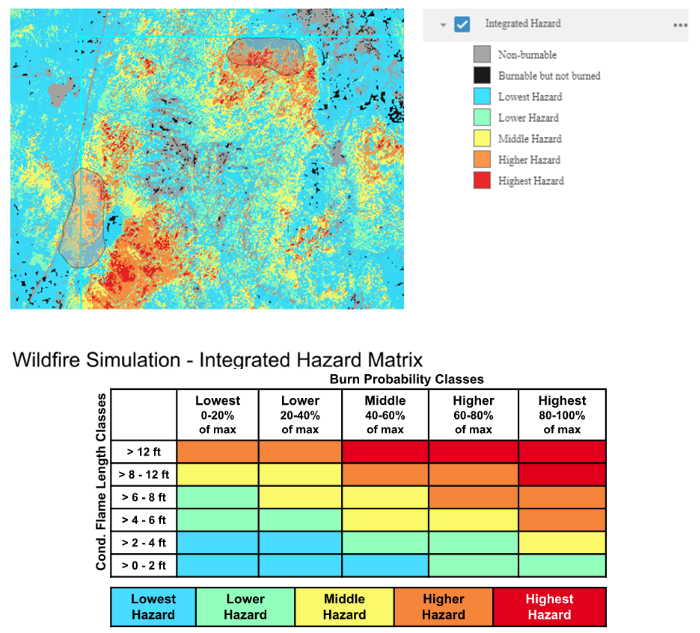
Note: This is brief summary of the more detailed Fire Behavior Model Comparison topic.
Whether you choose to run Landscape Burn Probability (LBP) or Landscape Fire Behavior depends on the questions you are trying to answer. See the table below for examples of questions that can be answered by one or both of the models.
| Landscape Burn Probability | Landscape Fire Behavior |
|---|---|
| Which areas on the landscape are more likely to burn than others? | Which areas on the landscape are more likely to experience crown fire vs. surface fire? |
| How likely is my ownership to burn as compared to likelihood on immediately adjacent ownerships and inholdings? | Which areas have fuels that result in the fastest spreading fires? |
| Which areas will burn with the highest intensity and severity? | |
| Which areas on this landscape would benefit from treatments with objectives of reducing fire intensity in areas that are most likely to burn? | |
The two models also approach fire behavior modeling differently. Landscape Fire Behavior models head fire only and each pixel is assigned fire spread independently. This results in higher fire intensity. Landscape Burn Probability takes into account heading, backing and flanking fire, as well as the influence of neighboring pixels which can result in lower intensity.
| Landscape Burn Probability | Landscape Fire Behavior |
|---|---|
| Probabilistic - randomness in ignitions and spotting means results may vary slightly given the same inputs. | Deterministic - the same inputs will always yield the same outputs. |
| Outputs are relative to the geographic extent of the landscape, they are uniquely scaled for each analysis or Area of Interest. | Changing landscape scale or masking outputs to an Area of Interest does not change model outputs. |
| Models head, flanking and backing fire. | Only models head fire. |
| Fire spread is modeled across pixels based on Minimum Travel Time algorithm. | Fire behavior calculated independently for each pixel. |
The LBP model is a tool that is available to help address a variety of fuels planning and wildland fire management questions. IFTDSS maps and summary reports for this model may be helpful in the decision making process for treatment type, location, and prioritization when conducting NEPA or other analyses.
Landscape Burn Probability can help answer questions like:
- Which areas on the landscape are more likely to burn than others?
- How likely is my ownership to burn as compared to immediately adjacent ownerships and inholdings?
- Which areas will burn with the highest intensity?
- Which areas on this landscape would benefit from treatments with objectives of reducing fire intensity in areas that are most likely to burn?
- How do I decide which treatment area has a higher priority than another?
Example - How to use LBP to Prioritize Treatment Location within Your Project Area
Scenario: You are working on a Community Wildfire Protection Planning team and are tasked with helping to determine where in your county the likelihood of fire burning is highest during elevated fire danger. This is in an effort to prioritize where limited fuel reduction treatment funds should be allocated county wide.
Step 1: Create or upload a polygon representing your county and create a Landscape for your project area.

Step 2: Run the Landscape Burn Probability model.
- Wind and fuel moisture inputs should represent a worst case weather scenario (90th percentile or greater).
- Simulation Time should represent the duration of worst case burn period in hours.
- Spotting probability may be left at the default of 20% in many cases, however that value can be changed if needed.
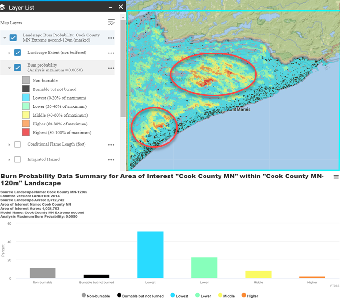
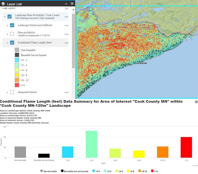
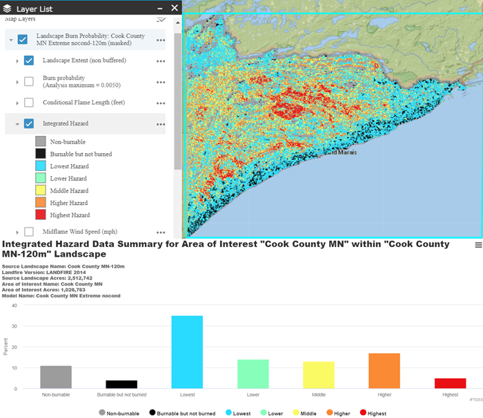
Step 3: Analyze outputs in the Map Studio and Reports and interpret. In this case:
-
Areas of highest Burn Probability are located in the center and southwest portion of the county.
-
Average Conditional Flame Lengths are fairly high across the entire county in areas away from the shore of Lake Superior.
-
When considering the likelihood of fire burning coupled with predicted intensity under extreme weather and fuel conditions, the areas in the central and southwest portion of the county seem to be the likely places to consider implementing fuel reduction treatments due because of elevated Integrated Hazard.
See the LBP Tutorial topic for step by step instructions on running LBP.

