Map Functions in Map Studio
This topic discusses how to us Map Studio. The bulk of your landscape editing and review will take place in the Map Studio.
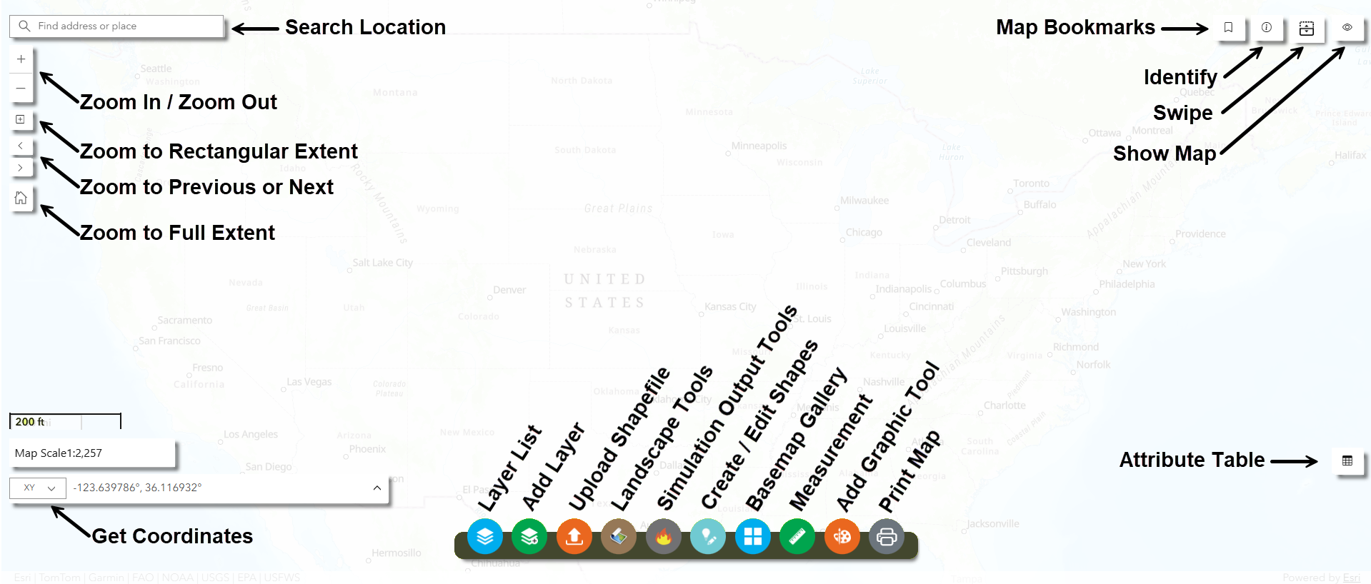
In the top left:
Map Studio Search ESRI: Enter a location to bring up a waypoint and zoom to its location on the map.
![]()
![]() Zoom in and Out: Zoom the map extent.
Zoom in and Out: Zoom the map extent.
![]() Zoom to Rectangular Extent: Draw a box to zoom to rectangular extent.
Zoom to Rectangular Extent: Draw a box to zoom to rectangular extent.
![]()
![]() Zoom to Previous our Next Extent: Return to previous zoom or next zoom extent.
Zoom to Previous our Next Extent: Return to previous zoom or next zoom extent.
![]() Zoom to Full Extent: Return the map to its full extent.
Zoom to Full Extent: Return the map to its full extent.
In the top right:
![]() Map Bookmark: Create a shortcut to a place on the map.
Map Bookmark: Create a shortcut to a place on the map.
![]() Identify: Identify a feature.
Identify: Identify a feature.
![]() Swipe: Allows for quick toggling between different layers.
Swipe: Allows for quick toggling between different layers.
![]() Map Overview: Allows to quick relocation of the map display area.
Map Overview: Allows to quick relocation of the map display area.
In the bottom left:
In the bottom right:
![]() Attribute Table: Displays a table of map features.
Attribute Table: Displays a table of map features.
In the bottom center:
![]() Layer List: A list of the layers shown on the map.
Layer List: A list of the layers shown on the map.
![]() Add Layers:Add previously uploaded or created shapes, or add IFTDSS reference layers to your Layer List.
Add Layers:Add previously uploaded or created shapes, or add IFTDSS reference layers to your Layer List.
![]() Upload Shapefile:Allows a user to upload a shapefile to IFTDSS.
Upload Shapefile:Allows a user to upload a shapefile to IFTDSS.
![]() Landscape Tools:Allows you to add an existing landscape, create a new landscape, or modify an existing landscape in the Map Studio.
Landscape Tools:Allows you to add an existing landscape, create a new landscape, or modify an existing landscape in the Map Studio.
![]() Simulation Output Tools:Allows you to add simulation outputs to the map, or compare results from multiple outputs.
Simulation Output Tools:Allows you to add simulation outputs to the map, or compare results from multiple outputs.
![]() Create / Edit Shapes: Make edits to existing map layers.
Create / Edit Shapes: Make edits to existing map layers.
![]() Basemap Gallery: A selection of basemap layers that can be added to the map.
Basemap Gallery: A selection of basemap layers that can be added to the map.
![]() Measurement: Allows you to measure area or distance in Map Studio.
Measurement: Allows you to measure area or distance in Map Studio.
![]() Add Graphic: Draw lines and shapes on the map. This is for display only, it does not create a shapefile.
Add Graphic: Draw lines and shapes on the map. This is for display only, it does not create a shapefile.
![]() Print Map: Print the map.
Print Map: Print the map.
